The Most Dramatic Canyon Hikes in North America
A Complete Guide to The Most Dramatic Canyon Hikes in North America
North America is home to many of the most famous and spectacular canyons on Earth. Over millions of years, rivers, floods, wind, and erosion carve deep chasms into the planet’s crust, slowly cutting through sandstone, granite and limestone. This powerful geological process creates towering cliffs, narrow slot canyons, hidden oases and mysterious labyrinths of sculpted rock. For hikers, canyons offer some of the most visually stunning and adventurous trekking options available.
MT Sobek has been a leading pioneer in adventure travel for more than 50 years, offering exceptional guided hiking tours across North America and the world since 1969. With award-winning adventure vacations in more than 60 countries, we are adamant that North America still contains some of our favorite all-time hikes. Although this continent is home to extraordinary mountain peaks, it is ultimately its canyons that set North America apart from other trekking destinations. In this article, we share with you our very favorite canyon hikes in North America because mountain peaks are special, but it is in the depths of canyons where you can discover true wonder.
“Mountain peaks are special, but it is in the depths of canyons where you can discover true wonder.”
From the immense scale of the Grand Canyon to the twisting slot canyons of Utah and the remote depths of Mexico’s Copper Canyon, hiking these areas reveals a different side of North America’s wilderness. Trails often descend into hidden worlds where rivers wind through stone corridors and ancient rock layers tell the story of geological time. For travelers seeking dramatic landscapes and memorable adventures, these canyon hikes represent some of the most extraordinary outdoor experiences in North America.
Table of Contents
- What Constitutes a ‘Canyon’?
- Grand Canyon’s South Kaibab Trail
- The Narrows in Zion
- Buckskin Gulch
- Havasu Falls and Havasu Canyon
- Copper Canyon Trek
- The Subway in Zion
- Chesler Park Loop in Canyonlands
- Grand Canyon of the Tuolumne
- Paria Canyon
- Black Canyon of the Gunnison
- Antelope Canyon Backcountry Routes
- Best Time of Year for Canyon Hiking
- Canyon Hiking Safety Tips
- Canyoneering vs Canyon Hiking
- How to Plan a Canyon Hiking Trip?
- Hike Independently or with a Trekking Guide?
What Constitutes a “Canyon”?
First, let’s define exactly what a canyon is. A canyon is a deep, narrow valley with steep sides, usually carved into the land by a river or intermittent flooding over millions of years. As water flows downstream—continually or in sudden, violent bursts—it gradually erodes the rock and terrain, cutting deeper and wider into the earth and creating the dramatic cliffs and exposed geological layers that characterize canyon landscapes. Wind, weather, freeze-thaw cycles and erosion also contribute significantly to shaping canyons over time.
Some of the most famous examples include Grand Canyon National Park, where the Colorado River has carved nearly a mile-deep gorge through ancient rock layers, and the colossal sandstone canyons of Zion National Park. Canyons vary widely in size and shape—from immense chasms stretching for miles to narrow slot canyons hundreds of feet long.
Grand Canyon’s South Kaibab Trail
Mileage: 3–21 miles depending on turnaround point or loop option
Difficulty: Moderate to Extremely Strenuous
Starting Trailhead: South Kaibab Trailhead
Ending Trailhead: South Kaibab Trailhead, Bright Angel Trailhead or North Kaibab Trailhead
Gateway Town: Tusayan, Arizona
Permits Required: No permit for day hiking; backcountry permit required for overnight stays below the rim
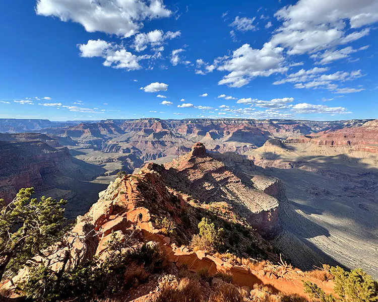
No canyon hike in North America is more iconic than descending into Grand Canyon National Park. Standing on the rim, the canyon appears almost impossibly vast – a seemingly endless maze of rock walls, side canyons, plateaus, buttes and spires. Mile-deep, stair-stepping cliffs stretch to the horizon in red, brown, orange and gold layers.
Hiking below the rim in the Grand Canyon reveals the Canyon’s true depth. As you descend, you are hiking through rock layers that are hundreds of millions of years old. The youngest rock layer—Kaibab Limestone—is 250-270 million years old. It’s so old dinosaurs did not yet exist when it formed! At the bottom of the Canyon, there are layers over 2 billion years old—nearly half the age of Planet Earth!
No trail captures the magnificence of the Grand Canyon with as much raw exposure combined with accessibility as the South Kaibab Trail. It follows an exposed ridge through the geological layers, allowing for panoramic views in all directions. There are multiple turn-around points on this trail, including Cedar Ridge (3 miles roundtrip), Skeleton Point (6 miles roundtrip), the shores of the Colorado River (13 miles round trip or 17 miles as a loop coming back up the Bright Angel Trail), or the North Kaibab Trailhead if hiking rim to rim (21 miles total as a thru-hike.)
Hiiking the South Kaibab Trail is dramatic from start to finish. Narrow ridges, dramatic viewpoints, and sprawling, maze-like desert landscapes make every step unforgettable. Spending the night at historic Phantom Ranch or camping below the rim allows hikers to experience the canyon after dark, when imposing cliffs are silhouetted against a deep black, star-lit sky.
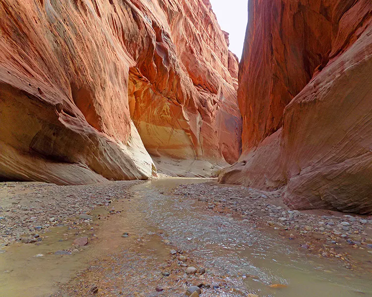
The Narrows in Zion
Mileage: 5–9 miles roundtrip bottom-up; 16 miles top-down
Difficulty: Moderate to Strenuous
Starting Trailhead: Temple of Sinawava (bottom-up) or Chamberlain Ranch (top-down)
Ending Trailhead: Temple of Sinawava
Gateway Town: Springdale, Utah
Permits Required: Permit required for top-down route; no permit for bottom-up day hike
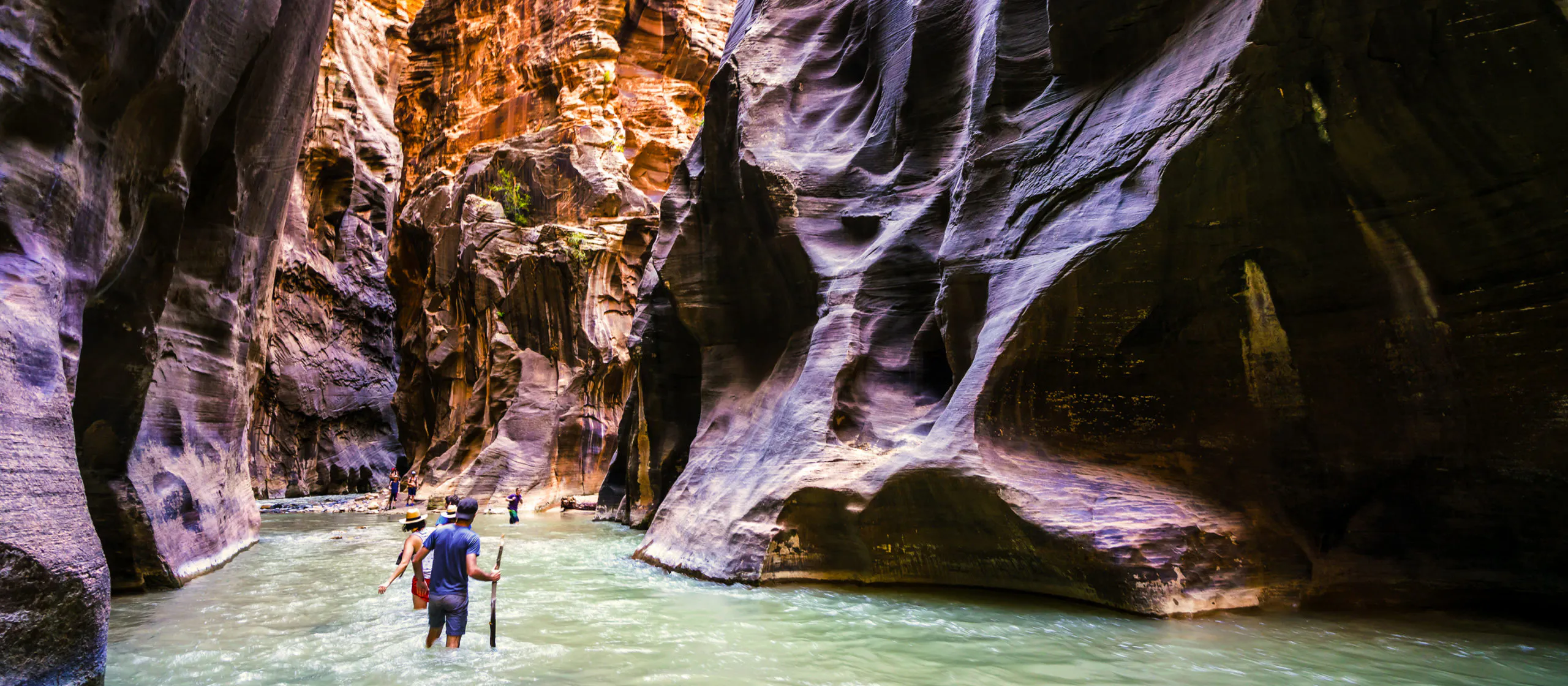
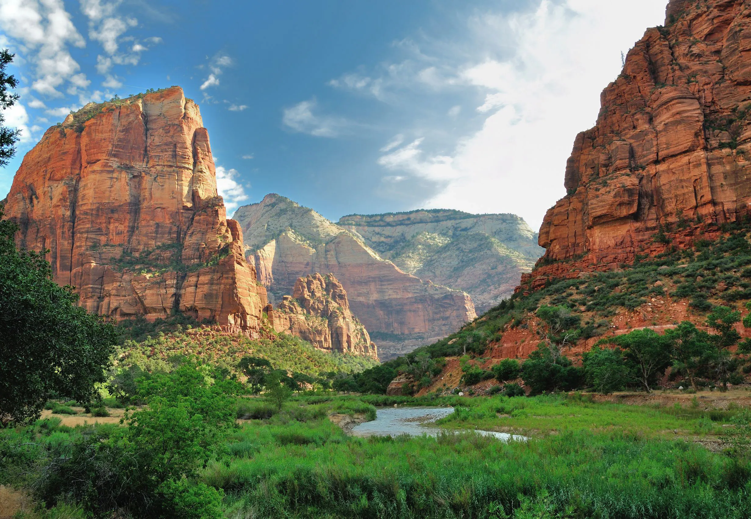
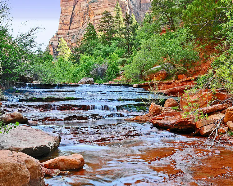
One of the most iconic and worthwhile hikes in the American Southwest is The Narrows in Zion National Park. Instead of following an established trail, hikers walk directly in the Virgin River as it winds through steep sandstone walls rising up abruptly from both sides of the river.
In some places the canyon narrows to only a few dozen feet wide while the cliffs stretch more than a thousand feet above the river. Light filters down into the canyon in mesmerizing patterns, illuminating intricate patterns etched into the sandstone over millions of years.
This hike does require walking in the water, so be prepared to get your feet wet. Some people prefer wearing active sandals or water shoes. The polished river rocks that you are walking on are also very slick, so tread carefully and use a walking stick or trekking poles to assist with balancing.
The Narrows in Zion hike can be done as a short day trip (5-9 miles roundtrip) or as a longer top-down canyon trek (16 miles point-to-point hike with a technical descent and permits required). Either way, the experience of walking through the clear, rushing water of the Virgin River between imposing canyon walls makes The Narrows without question one of the most dramatic canyon hikes in North America.
Buckskin Gulch
Mileage: 12–21 miles depending on the route
Difficulty: Strenuous
Starting Trailhead: Wire Pass Trailhead
Ending Trailhead: White House Trailhead
Gateway Town: Kanab, Utah
Permits Required: Day-use or overnight permit required through BLM
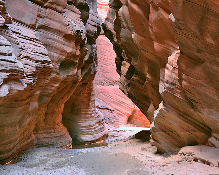
Located in the gorgeous desert of southern Utah, Buckskin Gulch is considered by many to be the longest slot canyon in the world. This extraordinary canyon slices through the desert landscapes near the spectacular Paria Canyon-Vermilion Cliffs Wilderness on the Arizona-Utah border.
On a long day hike or multi-day backpacking adventure, hikers travel for miles through a winding corridor of beautifully polished and sculpted sandstone passages. In some sections the canyon walls close to just a few feet wide while soaring hundreds of feet overhead.
Buckskin Gulch is a natural labyrinth, where light and shadow constantly dance across the canyon walls. The experience of hiking Buckskin Gulch is both mysterious and awe-inspiring, making it one of the most unforgettable canyon hikes in North America.
Havasu Falls and Havasu Canyon
Mileage: 20–30 miles depending on itinerary
Difficulty: Strenuous
Starting Trailhead: Hualapai Hilltop
Ending Trailhead: Hualapai Hilltop
Gateway Town: Seligman, Arizona
Permits Required: Reservation and permit required through the Havasupai Tribe
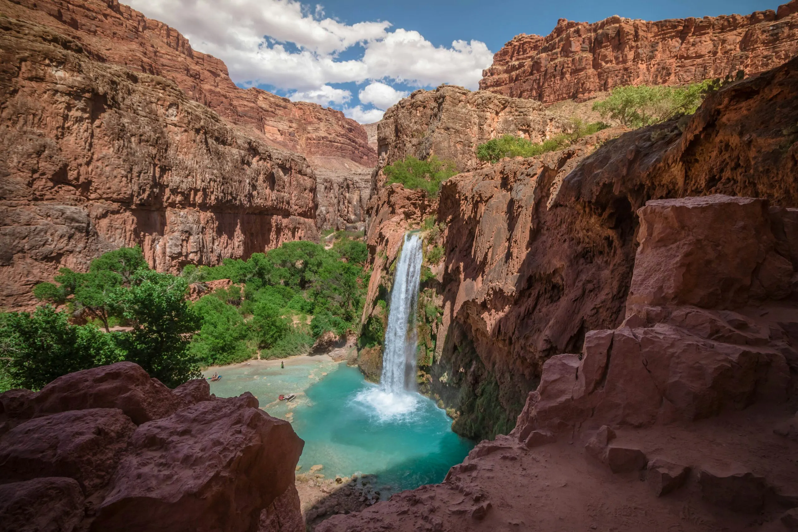
Hidden deep within the western Grand Canyon in Arizona lies one of the most beautiful waterfall hikes in North America: Havasu Canyon.
Located on the lands of the Havasupai Reservation and the Havasupai people, this hike leads visitors through a dry desert canyon for 6 miles before revealing the brilliant turquoise waters of Havasu Creek. The creek bubbles up out of deep limestone caverns and flows down-canyon over 5 spectacular waterfalls: Fifty Foot Falls, Navajo Falls, Havasu Falls, Mooney Falls and Beaver Falls. Mooney Falls is the tallest at 200 feet in height!
The vivid blue-green color of the water comes from high mineral content in the limestone, which also forms travertine pools and deposit formations that add to the mystique of this spectacular creek. Cascading waterfalls plunge into clear pools surrounded by red canyon walls, creating one of the most photogenic and utterly surprising landscapes in the American Southwest.
Havasu Falls is a 10-mile hike each way (8 miles to the village of Supai). It cannot be done as a day hike due to local regulations, and it is most often completed as a 3 or 4 day trip. There is a campground below Havasu Falls for backpackers and also a lodge in the village of Supai for those fortunate enough to secure rooms. Reservations for both the campground and the lodge are extremely competitive, normally open up in January or February, and sell out for the entire year in a couple hours.
Copper Canyon Trek
Mileage: 20–60+ miles depending on route
Difficulty: Strenuous
Starting Trailhead: Varies by trek
Ending Trailhead: Varies by trek
Gateway Town: Creel, Mexico
Permits Required: Generally no hiking permits required, though guided access is highly recommended
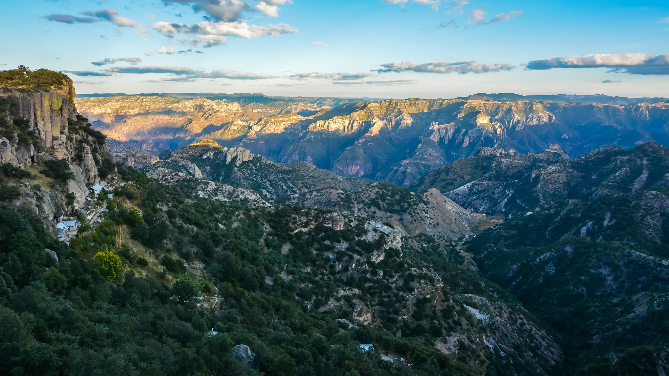
Often compared to the Grand Canyon but far less visited, Copper Canyon is one of the largest canyon systems in the world.
Located in the Sierra Madre mountains of Mexico, the canyon system is actually a network of six major canyons that together cover an area larger than the Grand Canyon, and that are arguably just as spectacular.
Hiking here often involves traveling between remote villages inhabited by the Rarámuri (also known as the Tarahumara) people, whose culture has for centuries been intertwined with long distance running through the rugged canyon environment. The best-selling book by Christopher McDougall “Born to Run,” took the Rarámuri’s regional renown and exploded it across the globe, highlighting not only their long-running traditions but their joyful culture and canyon lifestyles as well.
To hike Copper Canyon, you can essentially choose your own route. You can stay in lodges in Urique, Batopilas or other wonderful, small towns. Day hike to waterfalls, viewpoints, rivers and remote corners of the complex canyon systems. You can combine hiking with trains, zip lines and via ferratas. The options for adventure are limitless.
There is significant cartel activity in the Copper Canyon region, so it’s recommended to travel during the day, avoid bars and nightclubs, and hire local guides. The area is considered safe for tourists who mind their own business and make smart decisions. The upside to this reality is that many people avoid Copper Canyon, which means you’re likely to have it mostly to yourself when visiting.
The combination of dramatic canyon scenery, charming cultural immersion, and remote wilderness makes Copper Canyon one of North America’s most unique, spectacular and often overlooked hiking destinations.
The Subway in Zion
Mileage: 9 miles upstream; 9.5 miles downstream
Difficulty: Strenuous to Very Strenuous & Technical
Starting Trailhead: Left Fork Trailhead or Wildcat Canyon Trailhead (downstream)
Ending Trailhead: Left Fork Trailhead
Gateway Town: Springdale, Utah
Permits Required: Zion wilderness permit required for all routes
Another remarkable canyon adventure in Zion National Park is the hike known as The Subway.
Named for its smooth, circular sandstone chamber, this hike follows a twisting canyon carved over millions of years by flowing water. Along the way you scramble over boulders, wade through streams, and navigate narrow passages. The highlight is the iconic Subway chamber, where water pools beneath curved sandstone walls shaped by centuries of erosion.
The Subway can be done as a day hike if done upstream, or as a canyoneering adventure if done downstream. Either way a Zion wilderness permit is required.
The upstream hike is a strenuous, 9-mile hike that requires walking in water and negotiating large boulders. The downstream route is a 9.5-mile, technical canyoneering adventure that requires swimming and rappelling. The downstream route is not recommended unless you have extensive experience with technical canyoneering.

Chesler Park Loop in Canyonlands
Mileage: 10–11 miles
Difficulty: Moderate to Strenuous
Starting Trailhead: Elephant Hill Trailhead
Ending Trailhead: Elephant Hill Trailhead
Gateway Town: Moab, Utah
Permits Required: No permit for day hikes; overnight permits required for backpacking
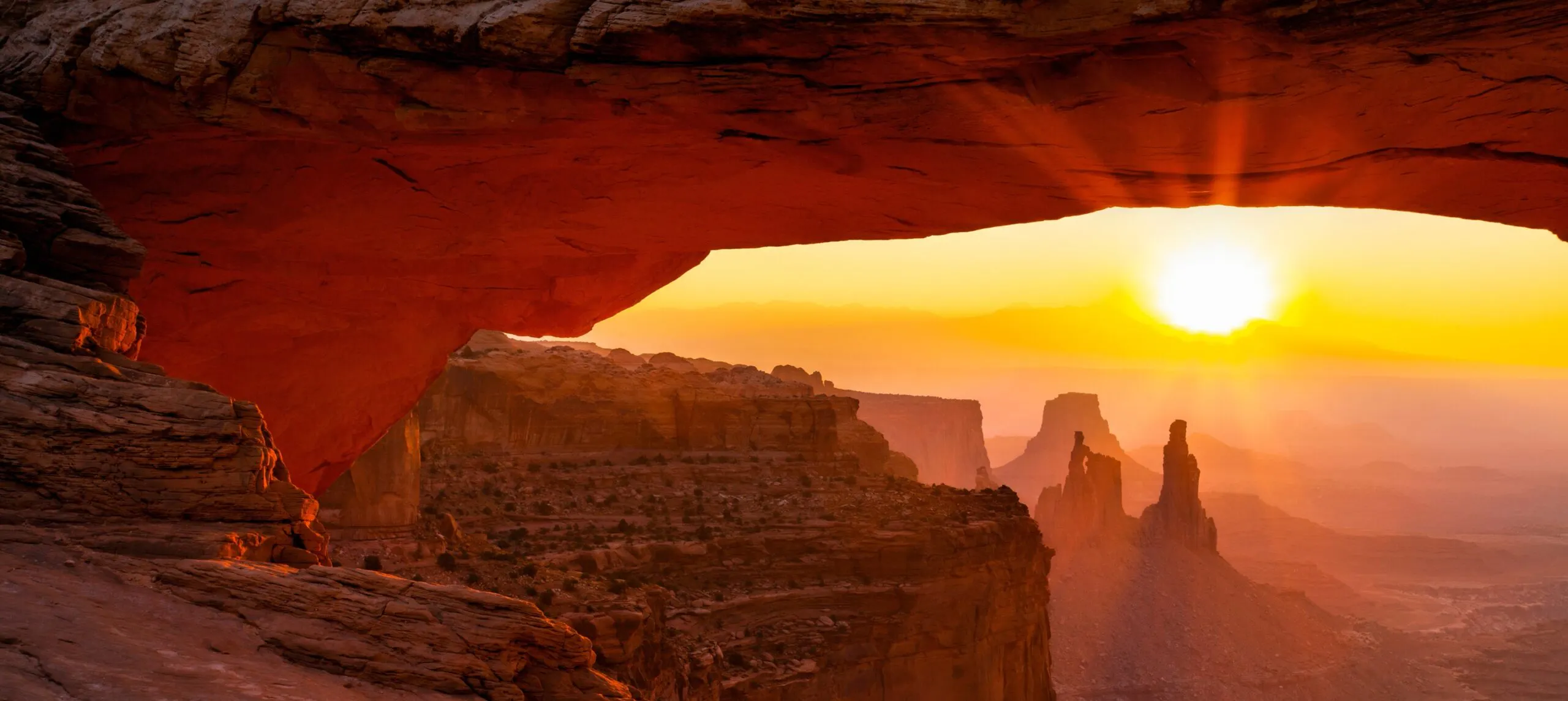
The Needles District of Canyonlands National Park offers one of the most surreal desert landscapes in North America.
The Chesler Park Loop winds through an intricate maze of imposing sandstone spires, tight corridors, and exposed desert landscapes. Trails weave between rock formations that resemble giant stone needles sprouting from the desert floor.
This hike is demanding, so be prepared for a long day on the trail. The trail climbs through rough terrain to a higher elevation meadows ringed by sandstone spires. Perhaps the most exciting and unique part of the hike is still coming at this point—navigating very tight corridors (2-3 feet wide) that are fractures in the rock. Eventually, the trail loops back to your starting point at Elephant Hill Trailhead.
The scale of the landscape and the sense of remote wilderness make the Chesler Park Loop one of the most rewarding canyon hikes in Utah.
Grand Canyon of the Tuolumne
Mileage: 30–35 miles
Difficulty: Strenuous
Starting Trailhead: White Wolf or Tuolumne Meadows
Ending Trailhead: Tuolumne Meadows or White Wolf
Gateway Town: Groveland, California
Permits Required: Yosemite wilderness permit required
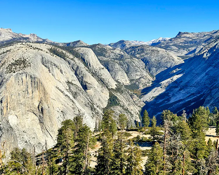
While most people associate Yosemite National Park with the monolithic granite cliffs and plunging waterfalls of Yosemite Valley, one of the park’s most spectacular and lesser-known adventures feels far more remote. The Grand Canyon of the Tuolumne route follows the powerful Tuolumne River through a dramatic granite canyon carved deep into the Sierra Nevada Mountains.
The hike descends from the high country of Tuolumne Meadows into a rugged canyon filled with roaring cascades, polished granite walls, and idyllic swimming holes. Highlights include a series of spectacular waterfalls such as Waterwheel Falls and LeConte Falls, where the river surges through narrow, rocky pinch-points. The hike is often completed as a multi-day backpacking trip, allowing hikers to explore one of the wildest and most scenic routes in Yosemite.
What makes the Grand Canyon of the Tuolumne especially memorable is the contrast between Yosemite’s famous areas in The Valley and this quieter, wilder canyon environment higher in the mountains. Granite cliffs soar above the river, wildflowers bloom in alpine meadows near the canyon rim, and the sound of rushing water echoes through the valley. For experienced hikers seeking a dramatic canyon trek in the Sierra Nevada, it is one of the most rewarding treks in North America.
The Grand Canyon of the Tuolumne hike is a multi-day backpacking trip. Backcountry camping permits are required and issued by Yosemite National Park via a lottery system.
Paria Canyon
Mileage: Approximately 38 miles
Difficulty: Strenuous
Starting Trailhead: White House Trailhead or Wire Pass
Ending Trailhead: Lee’s Ferry
Gateway Town: Kanab, Utah
Permits Required: Permit required through BLM lottery system
The Paria Canyon-Vermilion Cliffs Wilderness offers one of the more extended canyon hiking experiences in North America. Traversing Paria Canyon is a multi-day trek that follows the Paria River as it winds through seemingly endless sandstone slot canyons, past stunning rock formations, and into open high desert basins.
Unlike many canyon hikes that follow established trails, hiking Paria Canyon is done by walking directly in the riverbed much of the time, often in the water itself. The 4-5 day backpacking trip reveals sculpted cliffs, hidden alcoves, and striking geological patterns created by thousands of years of erosion. With a remote wilderness setting and breathtaking scenery, Paria Canyon is widely considered one of the premier backcountry hiking routes in the American Southwest.
Paria Canyon is done as a multi-day backpacking trip. Permits are required and are issued by the Bureau of Land Management via a lottery system on rec.gov.
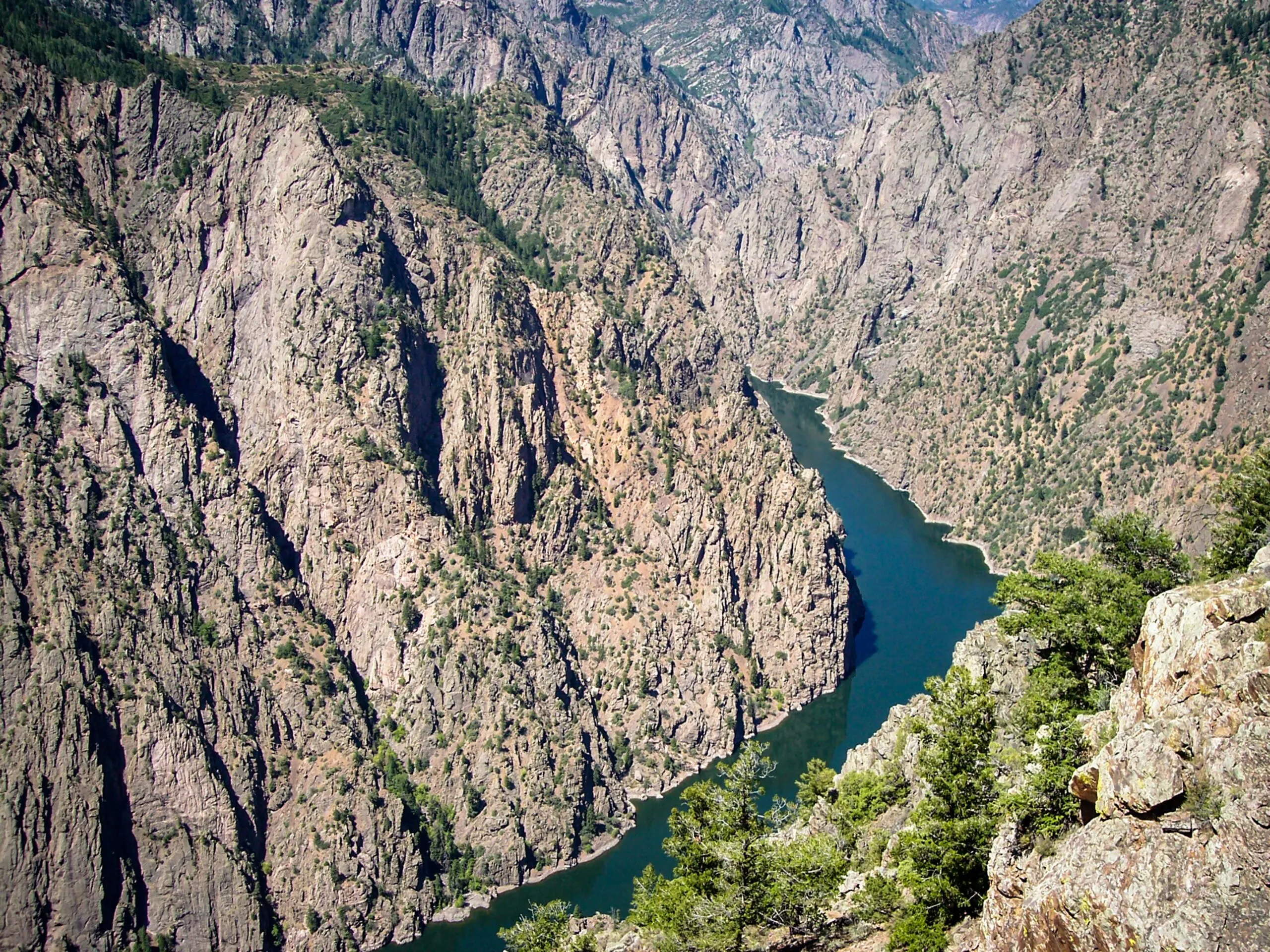
Black Canyon of the Gunnison
Mileage: 2–7 miles depending on wilderness route
Difficulty: Extremely Strenuous
Starting Trailhead: Various wilderness routes on South Rim
Ending Trailhead: Same as start
Gateway Town: Montrose, Colorado
Permits Required: Free wilderness permit required for inner canyon routes
Few canyons in North America feel as raw and powerful as the Black Canyon of the Gunnison National Park. Carved by the Gunnison River through ancient igneous rock (gneiss and schist), this canyon features some of the steepest cliffs and narrowest canyon walls in North America.
While many visitors admire the canyon from scenic overlooks, more adventurous hikers can descend steep wilderness routes into the canyon itself. These rugged trails lead to the river at the bottom, revealing towering ink-black cliffs that rise dramatically above the canyon floor. The remote wilderness setting and sheer scale of the landscape make this one of the most intense canyon hiking experiences in North America.
Antelope Canyon Backcountry Routes
Mileage: 1–6 miles depending on guided route
Difficulty: Easy to Moderate
Starting Trailhead: Guided access points near Page
Ending Trailhead: Same as start
Gateway Town: Page, Arizona
Permits Required: Guided tour reservation required through Navajo Nation Parks & Recreation
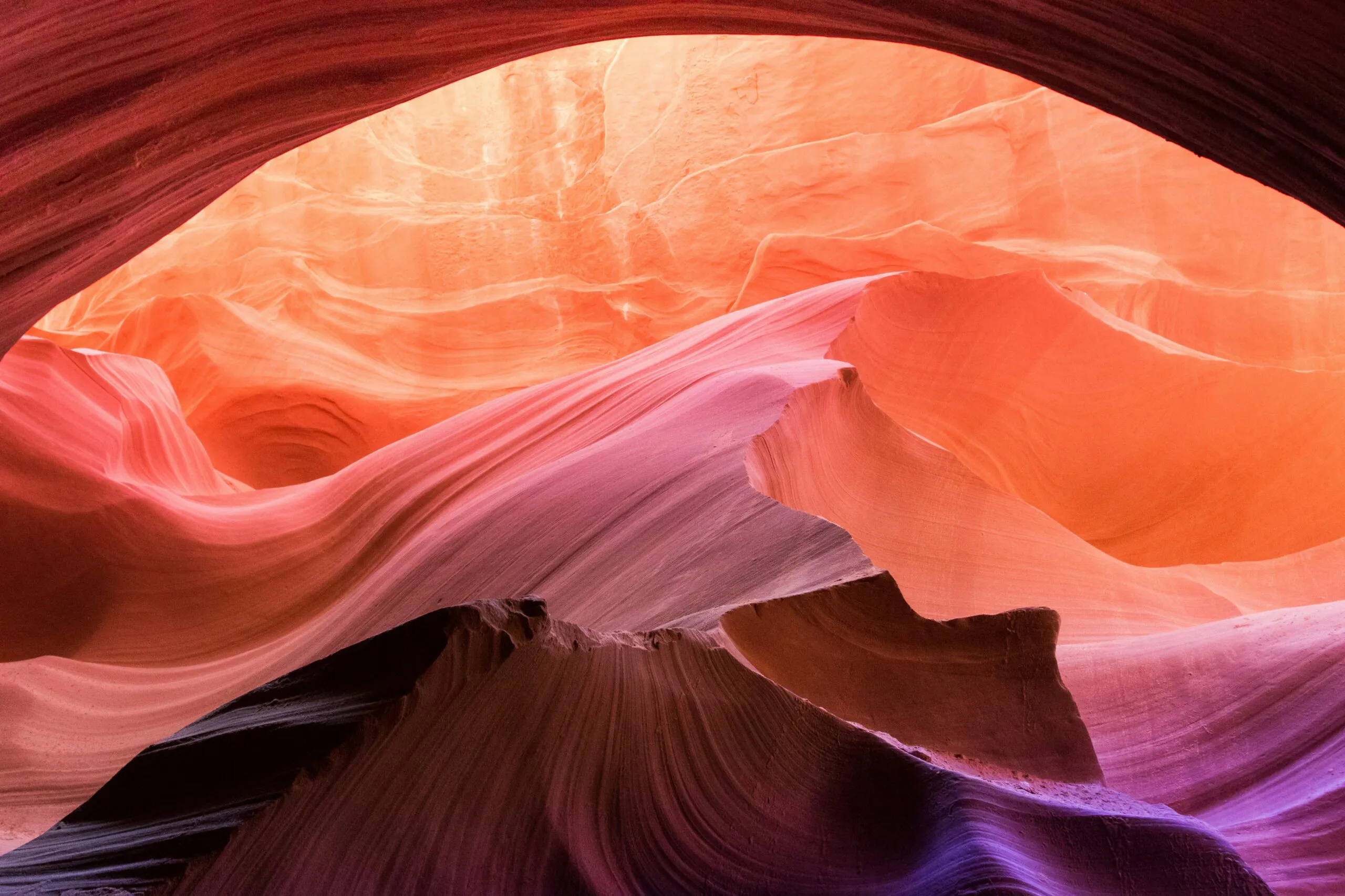
Located near Page, Arizona, Antelope Canyon is a very famous slot canyon system, and justifiably so. The canyon’s smooth, wave-like sandstone walls glow with rich shades of red, orange, and yellow as sunlight filters through narrow windows above.
While the most visited sections are guided sightseeing routes, the surrounding Navajo Nation lands offer additional guided backcountry hiking opportunities through lesser-known slot canyons. Exploring these narrow corridors reveals the extraordinary beauty created by flash floods and centuries of erosion in sandstone landscapes.
For many travelers, walking through the twisting landscapes of Antelope Canyon provides one of the most visually stunning canyon experiences anywhere in North America.
To hike Antelope Canyon, you must reserve a guided hike through the Navajo Nation’s Parks and Recreation Office.
Best Time of Year for Canyon Hiking
The best time to hike canyons in North America depends largely on elevation, latitude, and climate. Because many of the continent’s most dramatic canyon systems are located in desert environments, temperature is the biggest factor affecting when hiking is most comfortable and safe.
Spring (March–May)
Spring is widely considered the best overall season for canyon hiking in the American Southwest. Temperatures are typically mild, desert wildflowers may be blooming, and water levels in rivers and streams are often manageable. This is an ideal time to explore the canyon landscapes of Zion National Park, Canyonlands National Park, and Grand Canyon National Park.
However, spring hikers should still be aware of occasional storms and rapidly changing conditions, especially in narrow slot canyons where flash flooding is possible.
Summer (June–August)
Summer can be challenging for many canyon hikes in the Southwest because daytime temperatures often exceed 100°F and it is monsoon season. The inner gorge of the Grand Canyon, for example, can become extremely hot (110+ degrees fahrenheit in the shade) during midsummer and prone to sudden, intense thunderstorms. Deep in the sinuous passages of a slot canyon, even a hot summer day can be quite cool, especially if there is water. However, if there is any chance of rain in the forecast, it’s best to avoid slot canyons due to flash flood danger.
Summer is an excellent time to explore higher-elevation canyon systems, including the Grand Canyon of the Tuolumne in Yosemite National Park and other alpine canyon hikes in the Sierra Nevada or Rocky Mountains. In these regions, snow has melted from trails and temperatures remain comfortable for long days on the trail.
Fall (September–November)
Fall is another outstanding season for canyon hiking. Temperatures cool across the desert Southwest, making long hikes possible again. Crowds often decrease after summer, and the lower sun angle creates dramatic lighting against canyon walls.
Autumn is particularly beautiful in places like Zion and the Escalante region of southern Utah, where cottonwood trees along canyon rivers turn beautiful shades of gold.
Winter (December–February)
Winter can be a surprisingly good time to hike desert canyons. Cool temperatures make strenuous hikes more comfortable, and visitor numbers drop significantly.
Snow occasionally dusts the red rock landscapes of Zion or Bryce Canyon, creating striking scenery. However, winter hikers should be prepared for shorter daylight hours and occasional icy conditions on shaded trails.
Slot canyons that hold water in the winter can be dangerous or require the use of an insulated layer designed for use in water, such as a wetsuit. Becoming wet for an extended period of time in a slot canyon without direct sunlight can lead to hypothermia.
Canyon Hiking Safety Tips
Canyon environments are beautiful but can also present unique challenges for hikers. Proper preparation and awareness are essential for a safe and enjoyable experience.
Watch for Flash Floods
Flash floods are one of the most serious hazards in canyon environments, particularly in narrow slot canyons. Storms many miles away can send sudden torrents of water through otherwise dry canyon washes.
Before entering a canyon, always check weather forecasts and avoid hiking in narrow slots if rain is predicted anywhere in the surrounding area.
Manage Heat and Hydration
In desert canyon environments, dehydration and heat exhaustion are legitimate risks. Summer temperatures can become extreme, particularly at lower elevations.
To stay safe:
- Start hiking early in the morning
- Carry more water than you think you will need (as much as 2 gallons per day for each person in extreme heat)
- Take frequent breaks in shaded areas
- Wear sun protection such as hats and lightweight clothing
- Eat twice the number of calories you are used to, and consume plenty of sweet, salty snacks or electrolyte drinks to avoid hyponatremia.
Know Your Route
Canyon trails can sometimes be difficult to follow, especially in remote wilderness areas. Unlike forested trails, canyon routes may cross bare rock, riverbeds, or sandy washes where path markers are minimal. Cell phone or GPS service can also be blocked by the canyon walls, making the use of technology difficult.
Always carry:
- a map or GPS device
- extra food and water
- a headlamp or flashlight
Be Prepared for Water Crossings
Many canyon hikes involve wading through rivers or streams. Water levels can vary depending on snowmelt and seasonal rainfall, so conditions may change from day to day.
Proper footwear and trekking poles help maintain stability while crossing flowing water.
Canyoneering vs. Canyon Hiking
What is the difference between canyoneering and canyon hiking? While canyon hiking involves exploring canyon landscapes on foot, canyoneering is a more technical form of adventure that often requires specialized skills and equipment like ropes and harnesses.
Canyon Hiking
Most canyon hikes involve walking along trails, scrambling over rocks, or occasionally wading through shallow water. These hikes are accessible to most hikers with reasonable fitness and preparation.
Examples of canyon hiking routes include:
- The Narrows in Zion National Park
- Paria Canyon in the Arizona–Utah desert
- Chesler Park in Canyonlands National Park
These hikes showcase dramatic canyon scenery without requiring advanced technical skills.
Canyoneering
Canyoneering, on the other hand, often involves navigating extremely narrow canyon passages that require climbing, rappelling, and swimming. Participants may use ropes, harnesses, helmets, and other technical gear to descend waterfalls or vertical canyon walls.
Popular canyoneering destinations include the slot canyons around Zion such as the full descent of the Narrows and the remote canyons of the Escalante region in southern Utah.
Because canyoneering routes can involve significant hazards such as waterfalls, flash floods, and difficult navigation, beginners are strongly encouraged to participate in guided trips or training courses before attempting technical routes.
How to Plan a Canyon Hiking Trip
Planning a canyon hiking adventure involves more than simply choosing a trail. Because canyon environments can be remote and rugged, thoughtful preparation is key to a successful adventure.
Choose the Right Season
Selecting the best season for your hike is one of the most important decisions when planning a canyon hike. Desert canyon destinations are generally best in the cooler months, while higher-elevation canyon hikes are more suitable during summer.
Researching seasonal conditions will help ensure comfortable temperatures and accessible trails.
Understand Permit Requirements
Many popular canyon hiking destinations require permits to protect fragile desert ecosystems and manage the number of visitors.
For example, overnight hikes in Paria Canyon require permits issued by land management agencies, while access to certain areas of the Grand Canyon and Zion also require reservations.
Checking permit requirements well in advance is essential when planning trips to popular destinations.
Pack the Right Gear
Because canyon environments often include rocky terrain, water crossings, and extreme sun exposure, hikers should pack appropriate gear.
Essential items include:
- sturdy hiking shoes or boots
- plenty of drinking water
- An abundance of sweet, salty snacks
- sun protection
- navigation tools
- emergency supplies
In remote canyon areas, hikers should also consider carrying satellite communication devices or emergency beacons.
Know Your Limits
Some canyon hikes involve long distances, steep climbs, or challenging navigation. Planning a route that matches your fitness level and experience will help ensure the trip remains enjoyable and safe.
For beginners, starting with shorter canyon hikes or guided trips can be an excellent way to gain experience before attempting more remote or strenuous routes.
Hike Independently or with a Trekking Guide?
Many of North America’s most dramatic canyon hikes can certainly be completed independently by experienced hikers, but others are significantly safer, more enjoyable, and more logistically manageable with a professional guide.
Well-marked trails in places like Grand Canyon National Park, Zion National Park, and Bryce Canyon National Park are accessible to strong, independent hikers who are comfortable with navigation, weather changes, hydration planning, and long descents and climbs. But many canyon environments across the Colorado Plateau and desert Southwest involve hidden trail junctions, flash flood danger, route-finding challenges, water scarcity, river crossings, permit systems, or technical terrain that can quickly turn serious.
Guided canyon hikes like MT Sobek tours also provide deeper insight into geology, Indigenous history, ecology, and backcountry safety while removing the stress of shuttle logistics, permits, and navigation. For iconic but demanding routes such as the top-down Narrows, remote Grand Canyon traverses, or lesser-known slot canyons in Utah, a guide can dramatically improve both safety and the overall experience. The best choice ultimately depends on your experience level, comfort with remote terrain, and whether you want a purely self-reliant adventure or a more immersive and educational canyon hiking experience.


Enjoying our content? Add MT Sobek as a Google Preferred Source.

FAQs
Some of the most dramatic canyon hikes include the Grand Canyon’s South Kaibab Trail, The Narrows in Zion National Park, Paria Canyon, and the Black Canyon of the Gunnison. Each offers unique terrain, scale, and geological features.
Spring (March–May) and fall (September–November) are ideal for canyon hiking due to milder temperatures and lower risk of extreme heat compared to summer.
Yes, many canyon hikes are beginner-friendly, especially rim trails and shorter routes. However, more advanced hikes involving steep descents, heat exposure, or water crossings require preparation.
Many popular canyon hikes require permits, especially for overnight trips, backcountry routes, or protected areas like the Grand Canyon, Zion, and Paria Canyon.
Essential gear includes plenty of water, sun protection, sturdy hiking footwear, snacks, navigation tools, and emergency supplies. For river hikes, water-resistant gear is also important.
Key risks include heat exhaustion, dehydration, flash flooding, navigation challenges, and steep terrain. Preparation and awareness are critical.
Canyon hiking involves walking and scrambling through canyon terrain, while canyoneering includes technical activities like rappelling, climbing, and swimming.
Yes, guided trips provide expert knowledge, safety, navigation, and logistical support, especially for complex or remote canyon environments. Join us on a MT Sobek guided canyon hike tour!